CVOC 2019 Diet Adventure Race and Foot Orienteering
The meeting took place at the Heart of Virginia Council, Camp T. Brady Saunders, which serves as the Council's Boy Scout Resident Camp. The camp spans 720 acres of rolling Piedmont woodlands, featuring two lakes (Dillon and Olga) and several streams that flow through the property. Mark Walmsley was the course setter.
 |
| CVOC AR & Foot-O Course Map |
The advanced course covered both the traditional Boy Scout and Cub Scout camps. Any of us who spent any time as a Scout or a Scouter finds Camp T. Brady Saunders a special place. Out on the course, I remembered my time as a Scout going through my OA ordeal and providing selfless service to the camp. Can't forget Ranger John and his stories at the campfire.
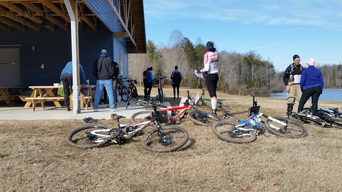
Pictured above is the start/finish line at the new STEM center. Both adventure racers and foot orienteers tell their war stories from the course. (12 racers did the Diet Adventure Race Course. 6 Beginner, 11 Intermediate, and 9 Advanced did the foot orienteering courses).
The advanced foot-O course was 7.1 km from point to point. I am sure I covered more distance than that... What can make this course difficult is the mass of the network of trails and the fifteen campsites. Looking at the map, each one of the dotted circles is a Troop campsite area.
It might have taken me more time to use the network of trails, but I found this to be an easier process for me. I am not going to point it out on the map, but one of the features is the OA circle. Only members of the OA know where the OA circle is located. If you took the same route I did, you might have passed by this area.
One navigation error I made was at control 12. I came into control 12 from the power easement and the trail just above #12 on the map. I was just north of the blue square and had to work my way down to the control.
It took me a minute or two to figure out the terrain feature from control 12 to control 13. On the map, you will see two rows of green dots just right of #13. It is a parking lot with trees in the lot... So, what are some lessons I learned? I used a new compass for the first time. Don't do this on the course! More cross-country running. I can say this enough! The study features and gets better at reading the map as I go.
You don't see too many of these features on an orienteering map, but there is a rifle range. Can you find the rifle range?


Comments