Outdoor Activities and Skills While Practicing Social Distancing
 |
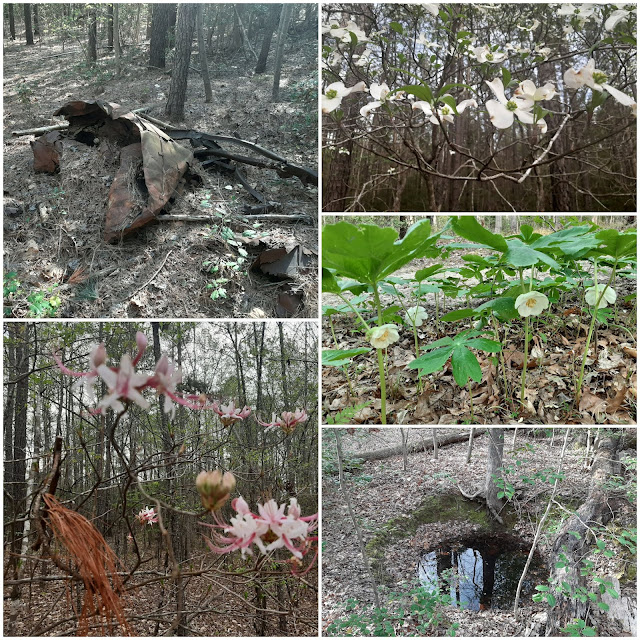
| Capturing the sites of the park. |
Following up on my last post, What Outdoor Adventure can you do During a Stay-at-Home Order? I wanted to share some of the different activities that I have been doing to keep within the guidelines of the order and to keep with social distancing.
Over the last few weeks, I have used a common-sense approach with my activities which reduces the risk of personal injury and follows the guidelines of social distancing. I started by setting a routine to conduct my outdoor activities and selected times that I felt were non-peak times that would limit my exposure to others. This routine also seems to work well with my remote work schedule and family. I have been able to do the following:
- Running
- Hiking
- Biking
- Rucking
- No gym workouts
- Social distancing volunteer project with Pocahontas State Park
- Epic adventures indoors with a mountain film festival.
- Made a music playlist for road trips
- Learn to use a new GPS
- Explored off-trail
- Learn how to use Caltopo
- Repair a mountain bike
- Avenza Maps and What3Words webinar
Best of all, none of the activities cost me anything. I either had the equipment or it was free, like the movies, music, and apps that I downloaded.
I am lucky to live next to Pocahontas State Park, which is an 8000-acre urban state park located 20 minutes south of Richmond Virginia. There have been a couple of nice weekend days I felt we were close to seeing the park close due to a lot of park users making it hard to keep up with the social distancing.
While all the regularly scheduled group volunteer projects have been canceled as a precaution against COVID-19, the park is offering an opportunity to continue volunteering at the required 6 feet of distance.
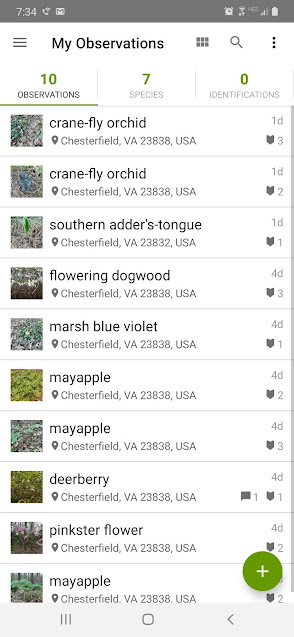
Using an app called iNaturalist, allows volunteers to document plants, animals, and fungi in the park. Any time spent documenting observations at Pocahontas State Park can be counted as volunteer hours.
The screen capture below is to the .iNaturalist website where you can load your observations there if you use a camera or you can update your observations with more details.
 |
| Screen capture of the iNaturalist website. |
 |
| My observations this week. |
There are projects all over the world that you can be a part of, and I am sure you can find something in your area. Who knows what you can find in your own yard or neighborhood? This is a great tool to learn to ID plants and animals.
I was able to catch a free webinar put on by Avenza Maps and What3Words. I have been using Avenza Maps for over a year now and I really like it. I am sure there are other mapping and navigation apps out there but I really like the fact that I can build and customize my own map. I feel this fits my needs better than what a navigation app might provide.
Avenza Maps and What3Words have partnered together and provided a different way to find a point on the map. Each 3-meter by 3-meter square on earth has 3 words assigned to it. An example is the Year.Blue.The street would be a 3-meter by 3-meter point. For me to tell you my location or a place that I need to go to you would use 3 words instead of providing some form of Lat/Long. The 3 words are easier to communicate. Avenza Maps has What3Words as a selection when choosing a Lat/Long type. To learn more about What3Words head over to their site
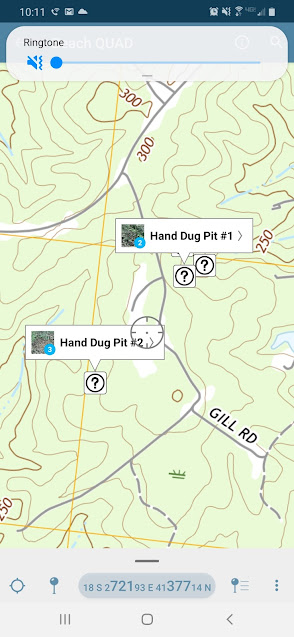
I used Avenza Maps to navigate and explore some interesting features that I had found in a layer of Caltopo.
 |
| Avenza Maps App. |
The points that I mapped here are pits or wells that I found in a layer of Caltopo which is a LiDAR layer. In the picture at the top of the post, you will see what one of those pits or wells looks like. It has been cool to learn how to use the Caltopo layer and go out and find what I saw in the map layer. I have a lot more locations to explore and learn the history of the people who lived in what is now a State Park.
Now It's Your Turn-
Your outdoor adventures and skills don't have to be put on hold. You just have to think about it differently. Please leave a comment on what you have been doing while social distancing or under a stay-at-home order.


Comments