Three Days on the C and O Canal
Editor's note: This article was originally published on 6 May 2012 and has been updated in August 2019 for accuracy and comprehensiveness.
After months of research and planning, I decided to ride the C& O Canal from Georgetown to Cumberland MD, and back unsupported. An out-and-back trip of about 370 miles. I can tell you that it did not go as planned and that's okay. What I want to do here is cover things that went right and things that I learned that will help others with their C and O Canal trip. I had ridden sections of the trail with my son's Scout Troop but had not done the whole trail. Plus I had support during those trips so that was a different experience.
I used 4 different resources to plan my trip Bike Washington, bikecando, National Park Service, C, and O Yahoo Group.
Just in the short time after I took those section trips with my son's Scout Troop, the economy has paid its toll on some of the businesses that riders used to support their trip to the C and O Canal. The bikewashington.org and bikecando sites were outdated and information about those businesses which had succumbed to the economy was not up to date. This caused me issues with resourcing supplies while on the trail.
While updating this post, I verified that all the resources I used still worked, and from what I can tell contain updated links to trailside resources like places to eat and places to stay. The Bike Washington site has an app available for the iPhone. bikecando seems to be updated with current trailside resources. One that I didn't use at the time was the C&O.Canal Trust as a resource. Bookmark their site as they are the official non-profit partner of the Chesapeake & Ohio Canal National Historical Park. Seven Lockhouses can be rented from their site which would make a unique experience for a night's stay on the trail. The C&O Trust also has an app available for both Android and iPhone.
Planning your starting point. This might be one of the biggest issues that you have to figure out and what works best for one might not be best for everyone. I started my epic adventure at the economy parking lot at the Reagan International Airport. You can search for cheap airport parking and find that there are some deals with the local hotels that provide long-term parking at their parking garage and they are just a short distance to the Mount Vernon Trail. So this can save you a few bucks.
Park near a row sign or under a parking lot light and either write it down or take a picture of where you parked your vehicle. With several hundred cars and miles behind you, the last thing you want to do is spend 30 mins looking for a car. After leaving the economy lot I head to the north left corner and there is a sidewalk opening to lead to back the road that you drove to get to the parking lot. The Mount Vernon trail is about 25 ft across the road. You will have about a five-mile
ride from the airport to Georgetown. The Mount Vernon Trail follows the
Potomac River and you get to see the National Monuments from the river.
Pro Tip: I don't use my credit card at any parking lot/garage with an attendant. I have had my credit card number stolen once when using a parking deck when I had to pay the attendant. I either use cash or if I can make the reservation online at home I will. You can also pay by a smartphone app for airport parking if you are comfortable with that.
The Bike Washington site has a good section on other transportation options. One of the best options that people had advocated for years was for Amtrak to provide a walk-on bike service. On
When I did this trip I didn't have the option to take my bike by train. Now I can take the train from Richmond Virginia to Union Station and then to Cumberland Maryland.

Planning your daily mileage. I figured I would have some good long days in the saddle. Since I was going solo on this trip I would have all day to ride. I also figured that I have done some 50 and 65-mile races in the four and five-hour time period and 80 miles in a day was doable. It's only a one percent grade for 184 miles. That is flat, right? It is and it looks like this.

You will be in the saddle all day! There are no hills other than the rise at a lock and the fall after one. When you stop pedaling then you stop. So one percent equals pedaling all the time... This might not seem hard but if you add bad weather or a headwind or just riding by your self it is going to be a hard day.
Then you run into this... There are detours all the time on the C&O Canal. Pay attention to these and what impact this might have on you.

Pushing a bike up a staircase might not be that big of a deal if you only have a spare tube and pump. Add bags and camping gear then it can become a herculean task.
If you are using trail-side stores for your lunch and dinner resupply, this may dictate your mileage for the day. My plan was to get me to Huckleberry Hill Hiker/Biker campsite just north of Harper's Ferry. This made for a 68.4-mile day which took 6 hours and 30 minutes.
Day Two starts off with the NPS maintenance crew coming by a check the pump well at the campsite. It was cold so I started my day in the tent cooking up some coffee and something to eat.

Now here's something that you need to know about the water in the pump wells. The Park Service treats the wells with iodine. It might be me but I don't care what you do it tastes like crap and will turn a weak tea brown in your water bottle. You might want to bring a little more cash with you and purchase the water off the trail or have a filter system.
I think you could spend the good part of a day in Harper's Ferry. I would say this is a must-see town. Take the two vehicles out of the picture and I am sure that is what it looked like 150 years ago.
How cool is this? The picture was taken at the confluence of the Potomac and Shenandoah River. It is cool seeing the water of each river mix into one.
I used my Field Notes Brand Notebook for this adventure as my map and trip journal. The notebook is about the size of a passport and I used it all the time since I put the NPS map in the back of the book (second picture).


Navigate over to read about the rest of my journey at Three Days on the C&O Part 2
After months of research and planning, I decided to ride the C& O Canal from Georgetown to Cumberland MD, and back unsupported. An out-and-back trip of about 370 miles. I can tell you that it did not go as planned and that's okay. What I want to do here is cover things that went right and things that I learned that will help others with their C and O Canal trip. I had ridden sections of the trail with my son's Scout Troop but had not done the whole trail. Plus I had support during those trips so that was a different experience.
I used 4 different resources to plan my trip Bike Washington, bikecando, National Park Service, C, and O Yahoo Group.
Just in the short time after I took those section trips with my son's Scout Troop, the economy has paid its toll on some of the businesses that riders used to support their trip to the C and O Canal. The bikewashington.org and bikecando sites were outdated and information about those businesses which had succumbed to the economy was not up to date. This caused me issues with resourcing supplies while on the trail.
While updating this post, I verified that all the resources I used still worked, and from what I can tell contain updated links to trailside resources like places to eat and places to stay. The Bike Washington site has an app available for the iPhone. bikecando seems to be updated with current trailside resources. One that I didn't use at the time was the C&O.Canal Trust as a resource. Bookmark their site as they are the official non-profit partner of the Chesapeake & Ohio Canal National Historical Park. Seven Lockhouses can be rented from their site which would make a unique experience for a night's stay on the trail. The C&O Trust also has an app available for both Android and iPhone.
Planning your starting point. This might be one of the biggest issues that you have to figure out and what works best for one might not be best for everyone. I started my epic adventure at the economy parking lot at the Reagan International Airport. You can search for cheap airport parking and find that there are some deals with the local hotels that provide long-term parking at their parking garage and they are just a short distance to the Mount Vernon Trail. So this can save you a few bucks.
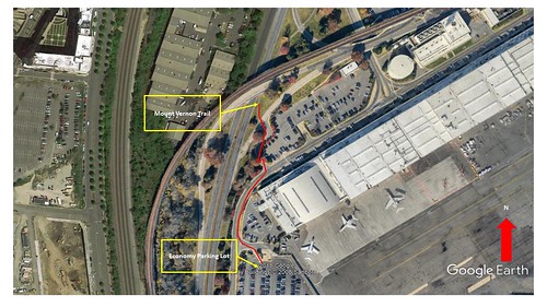 |
| Map overlay of the economy parking and route to the trail. |
Pro Tip: I don't use my credit card at any parking lot/garage with an attendant. I have had my credit card number stolen once when using a parking deck when I had to pay the attendant. I either use cash or if I can make the reservation online at home I will. You can also pay by a smartphone app for airport parking if you are comfortable with that.
The Bike Washington site has a good section on other transportation options. One of the best options that people had advocated for years was for Amtrak to provide a walk-on bike service. On
the Capitol Limited which services stop daily on the C&O. Reservations are required to use this service. In addition to your ticket price, the cost of the bike is $20. The Capitol Limited runs once per day which may not be convenient for some cyclists.
When I did this trip I didn't have the option to take my bike by train. Now I can take the train from Richmond Virginia to Union Station and then to Cumberland Maryland.

Planning your daily mileage. I figured I would have some good long days in the saddle. Since I was going solo on this trip I would have all day to ride. I also figured that I have done some 50 and 65-mile races in the four and five-hour time period and 80 miles in a day was doable. It's only a one percent grade for 184 miles. That is flat, right? It is and it looks like this.

You will be in the saddle all day! There are no hills other than the rise at a lock and the fall after one. When you stop pedaling then you stop. So one percent equals pedaling all the time... This might not seem hard but if you add bad weather or a headwind or just riding by your self it is going to be a hard day.
Then you run into this... There are detours all the time on the C&O Canal. Pay attention to these and what impact this might have on you.

Pushing a bike up a staircase might not be that big of a deal if you only have a spare tube and pump. Add bags and camping gear then it can become a herculean task.
 |
| Detour Route |
If you are using trail-side stores for your lunch and dinner resupply, this may dictate your mileage for the day. My plan was to get me to Huckleberry Hill Hiker/Biker campsite just north of Harper's Ferry. This made for a 68.4-mile day which took 6 hours and 30 minutes.
Day Two starts off with the NPS maintenance crew coming by a check the pump well at the campsite. It was cold so I started my day in the tent cooking up some coffee and something to eat.

Now here's something that you need to know about the water in the pump wells. The Park Service treats the wells with iodine. It might be me but I don't care what you do it tastes like crap and will turn a weak tea brown in your water bottle. You might want to bring a little more cash with you and purchase the water off the trail or have a filter system.
I think you could spend the good part of a day in Harper's Ferry. I would say this is a must-see town. Take the two vehicles out of the picture and I am sure that is what it looked like 150 years ago.
 |
| The historic streets of Harper's Ferry |
How cool is this? The picture was taken at the confluence of the Potomac and Shenandoah River. It is cool seeing the water of each river mix into one.
 |
| The confluence of the Potomac and Shenandoah Rivers |
I used my Field Notes Brand Notebook for this adventure as my map and trip journal. The notebook is about the size of a passport and I used it all the time since I put the NPS map in the back of the book (second picture).


Navigate over to read about the rest of my journey at Three Days on the C&O Part 2


Comments